


Karun IV Dam & Hydropower Plant Project

Project Purpose / Layout
The purpose of the project is to generate 2107 GWH hydroelectricity per annum and control floods. It helps to use a reservable quantity of water for agricultural consumption in the Khuzistan plain.

Geographic Location
Chaharmahal & Bakhtiari province – 160 km distance on Shahr-e-Kord – Izeh road.
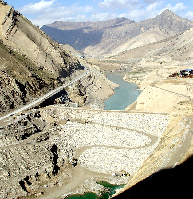
The Karun IV dam axis is located at 670 km downstream of the Karun River on the confluence of the Armand River and Bazoft River and upstream of the confluence of the Karun River and Monj River.
X = 449918.731 Y = 3496158.105

Project History
The preliminary studies were carried out by Harza International Consulting Engineers within the framework of water resources development project as well as general water resources plan of the Karun River. The phase I studies were assigned to Mahab Ghodss Consulting Engineering Company in 1993. A contract was signed between Mahab Ghodss Consulting Engineering Company and Iran Water & Power Resources Development Company for the phase II studies in 1997.

Specific Characteristics of Project
The Karun IV dam is the highest dam in Iran. It is situated upstream a chain of dams built on the Karun River. It is a concrete double curvature arch dam whose design, construction and operation phases are all conducted by Iranian experts for the first time as regards its considerable complexities.
The stability of the dam abutments was analyzed in particular with regard to the specific topographic features of the dam site, short extension and relatively low quantity of abutment rock mass. The comprehensive studies on the dam body and abutments were organized by employing Iranian and International competent experts. In the first step, all the geologic features were surveyed and the geomechanical parameters were scrutinized closely. Then shear strength of the major faults and joints were determined using Barton criterion.
The overall nonlinear static and dynamic analyses of the dam body and abutments were put on the agenda with the main purpose of studying the stability of the dam abutments and considering the interaction between the dam body and dam foundation. Accordingly, ABAQUS software was used to produce an overall three-dimensional model of the dam body in which the geometric figure of topography of the valley was regarded compliant with the natural conditions. Most geologic features such as major joints and discontinuities of the dam foundation together with contraction joints of the dam body were modeled too. The nonlinear analyses under static and dynamic conditions were carried out by the overall model.
The studies indicated stable abutment wedges which had been judged to be unstable in the event of an earthquake based on the conventional preliminary studies.

Technical Specifications of Project
|
Dam |
|
|
Dam type |
Concrete double curvature arch dam |
|
Dam height above foundation (m) |
232 |
|
Dam crest length (m) |
440 |
|
Dam crest width (m) |
7 |
|
Dam body volume (m3) |
1650 x 103 |
|
Total reservoir volume (m3) |
2232 x 106 |
|
Active reservoir volume (m3) |
827 x 106 |
|
Mean annual inflow (m3) |
4927 x 106 |
|
Spillways |
|
|
Type of spillways |
Gate spillway & Free spillway |
|
Flood discharge capacity (m3/s) |
8650 |
|
Powerhouse |
|
|
Powerhouse type |
Surface |
|
Number of units |
4 |
|
Design head (m) |
191 |
|
Installation capacity (MW) |
1000 |
|
Mean annual generation (GWH) |
2107 |
|
Excavation quantity of powerhouse (m3) |
1200,000 |
|
Concrete quantity of powerhouse (m3) |
156,000 |
|
Diversion System / Culvert |
|
|
Type of diversion system |
Diversion tunnel |
|
Number of diversion tunnels |
2 |
|
Total length of diversion system |
1364 m |
|
Discharge capacity of diversion system |
2715 (m3/s) |
|
Power Tunnel |
|
|
Length of power tunnel (m) |
1390 |
|
Diameter of power tunnel (m) |
12.6 m |
|
Discharge capacity of power intake tunnel |
684 (m3/s) |
|
Grouting Galleries |
|
|
Total length of grouting galleries (m) |
7130 |
|
Grout Curtain |
|
|
Total length of grouting and drilling (km) |
410 |
|
Relocation Roads & Access Roads |
|
|
Length of relocation roads (km) |
5 |
|
Length of access roads (km) |
4 |